
The riparian zone — the transitional area between a stream channel and the adjacent terrestrial landscape — is among the most ecologically complex habitats in central European lowlands and uplands. In Germany, its structure and condition are assessed through the Gewässerstrukturkartierung (GSK), a standardised physical habitat survey methodology developed by LAWA for use under the EU Water Framework Directive's hydromorphology quality element. The results feed into overall ecological status classification alongside biological and physicochemical assessments.
Intact riparian zones perform multiple functions simultaneously: they stabilise streambanks through root networks, intercept runoff from adjacent fields (reducing sediment and nutrient input to the channel), provide large woody debris (LWD) to the stream, shade the water surface to moderate temperature, and support characteristic plant and animal communities that use both aquatic and terrestrial habitats through different parts of their life cycles.
Structure of Riparian Zones in German Streams
The classical model of a riparian zone distinguishes several lateral zones from the low-water channel edge outward.
Active Channel and Bankfull Zone
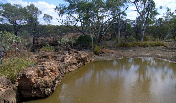
The active channel encompasses the wetted perimeter during base flow and is directly shaped by stream discharge. In gravel-bed streams of the Mittelgebirge, this zone is characterised by exposed gravel bars, moss-covered boulders, and patches of hydrophilous pioneer vegetation such as Myricaria germanica (German tamarisk) where it survives as a rare species on braided mountain rivers. Bank erosion and deposition occur episodically during high-flow events.
Riparian Scrub and Gallery Forest (Auenwald)
Beyond the bankfull level, the riparian zone is typically colonised by woody vegetation adapted to periodic inundation. In Germany, alluvial gallery forest (Auenwald) is dominated by alder (Alnus glutinosa) along small streams and by white willow (Salix alba) and black poplar (Populus nigra) along larger rivers. These trees tolerate waterlogged soils and brief inundation periods. The root systems of streamside alders contribute substantially to bank stability while creating undercut bank habitats used by brown trout and other fish for cover.
Auenwald covers only a small fraction of its original extent along German rivers. Large-scale riparian deforestation began in the eighteenth and nineteenth centuries as rivers were channelised for navigation and land reclaimed for agriculture. Today, restoration projects under the EU Biodiversity Strategy and the German National Biodiversity Strategy aim to re-establish continuity between stream channels and their floodplains.
Floodplain
The broader floodplain (Aue) extends beyond the gallery forest to the outer limits of periodic inundation during high-flow events. In relatively unmodified systems — including stretches of the Eder, Fulda, and some smaller Bavarian rivers — floodplains retain connections with the main channel through side channels, oxbow lakes (Altarme), and temporary wetlands. These habitats serve as spawning and nursery grounds for rheophilic fish species such as asp (Leuciscus aspius) and nase (Chondrostoma nasus), and as feeding grounds for migrating birds.
Floodplain connectivity has been severely reduced along most German rivers by flood protection embankments (Deiche) that prevent lateral overflow. The Elbe, Rhine, and Danube floodplains have been reduced by substantial proportions of their historical extent. Controlled dyke setbacks (Deichrückverlegungen), as implemented at several pilot sites along the Elbe, partially restore inundation dynamics and are monitored for ecological response.
The LAWA Gewässerstrukturkartierung
The Gewässerstrukturkartierung (GSK) is Germany's standard field survey for assessing hydromorphological quality of running waters. It was developed in two variants: one for medium-to-large rivers (LAWA-ÜK, overview scale) and one for smaller streams (LAWA-VK, detailed scale). The detailed variant is applied to streams and small rivers accessible on foot.
The survey records seven main parameter groups across 100-metre assessment units along the stream corridor:
- Bed substrate and structure — substrate diversity (gravel, sand, rock, fine sediment), presence of sand deposition, artificial reinforcement of the bed.
- Bed dynamics — evidence of lateral erosion and deposition, formation of gravel bars, and presence of riffles and pools.
- Cross-sectional profile — bank height, width variability, degree of incision or aggradation relative to the floodplain.
- Longitudinal continuity — barriers to fish passage (weirs, culverts, pipes), spacing between obstacles.
- Bankside land use — vegetation strip width adjacent to the water, agricultural use within 5 m of the bank, presence of bank reinforcement (rip-rap, sheet piling).
- Riparian vegetation — characterisation of bank vegetation type (gallery forest, shrub, grass, bare/reinforced), species composition indicators where visible.
- Riparian land use buffer — land use in the broader riparian corridor (10–30 m from water's edge) including field crops, pasture, urban structures.
Each parameter is scored on a seven-class scale from 1 (unmodified, reference condition) to 7 (completely altered). The weighted mean of individual parameter scores determines the overall structural quality class for each assessment unit. The GSK database maintained by the responsible Länder water authorities (Landesumweltämter) is updated periodically and feeds into reporting under the WFD.
Unlike biological assessments, which compare current species assemblages to type-specific reference communities, GSK uses historical documentary evidence (historical maps, aerial photography) and ecologically undisturbed reference reaches as benchmarks. For many German stream types, no unmodified reference sections exist; in these cases, near-natural reaches with minimal human influence are used as proxies.
Ecological Functions of Intact Riparian Zones
Nutrient and Sediment Interception
Vegetated riparian buffers intercept surface runoff and shallow subsurface flow from adjacent agricultural fields. Grasses, shrubs, and trees reduce flow velocity and promote infiltration and sedimentation, retaining a proportion of the nitrogen and phosphorus that would otherwise reach the stream. The efficiency of this interception depends on buffer width, soil type, slope, and precipitation intensity. German agri-environment schemes (Agrarumweltmaßnahmen) offer payments to farmers maintaining buffer strips adjacent to waterways, typically requiring a minimum width of 5–10 metres.
Thermal Regulation
Riparian tree canopy reduces direct solar radiation reaching the stream surface, limiting summer water temperatures. In small forested streams, shading can keep temperatures several degrees lower than in adjacent unshaded reaches — a difference that can determine whether a reach supports brown trout or is unsuitable for salmonids. Reforestation of stream corridors is therefore a component of climate adaptation strategies for German trout streams, particularly in lowlands where summer heat stress is projected to increase.
Large Woody Debris Input
Standing and fallen trees in the riparian zone contribute large woody debris to the stream channel. LWD creates hydraulic complexity — backwater eddies, pool formation, gravel bar sorting — and provides stable, long-duration habitat for invertebrates and fish. Under historical management, much of this material was removed from German streams to reduce flood risk and facilitate navigation. Contemporary restoration projects in Bavarian, Baden-Württemberg, and Hessian streams reintroduce LWD deliberately, with documented improvements in invertebrate diversity within a few growing seasons.
Major German Stream Types and Riparian Context
| Stream Type | Region | Natural Riparian Vegetation | Common Pressures |
|---|---|---|---|
| Coarse-substrate upland stream | Mittelgebirge (Eifel, Sauerland, Harz) | Alder gallery forest, bryophytes on substrate | Channelisation, bank reinforcement, forestry runoff |
| Sand-bed lowland stream | North German lowlands (Schleswig-Holstein, Brandenburg) | Willow, alder, reed beds | Agricultural drainage, sand extraction, nutrient loading |
| Calcareous spring stream (Quellbach) | Schwäbische Alb, Fränkische Alb | Tufa-forming bryophytes, watercress, carex | Spring impoundment, water abstraction, livestock access |
| Gravel-bed mountain river | Alpine foothills (Bavaria, Baden-Württemberg) | White willow, black poplar, Myricaria | Flood protection embankments, gravel extraction, hydropower |
| Peat-influenced lowland creek | Moors of Bavaria and northern Germany | Bog myrtle, sedge, brown moss | Drainage ditching, peat extraction, acid runoff |